
Sanctuary of Athena Camiras at Camirus

|
|
Athena and Erichthonius from Camirus (Click the image for a full screen view) |
Camirus History
The earliest traces of occupation in Camirus (also Kamiros or Kameiros) go back to the Mycenaean times, as is demonstrated by the cemetery discovered at the village of Kalavarda. Geometric and Archaic Camirus are known manly from cemeteries, located around the ancient city.
Findings from the Geometric period (8th c. BCE) testify the existence of a Temple dedicated to Athena on the Acropolis.
In 700 BCE Camirus was one of six cities of Dorian origin in Caria that gathered in a confederacy. It joined together with Lindus, Cos, Ialysus, Cnidus and Halicarnassus to found the Dorian Hexapolis (in Greek, "the six cities"). Having its common Sanctuary, a Temple to Apollo named the Triopion, on the promontory on which Cnidus is located.

|
|
Hexapolis map (Click the image for a full screen view) |
Few remains of the earlier Archaic city have been uncovered. Two headless Archaic kouroi (550-530 BCE) are now on display in the Museum of Rhodes, Greece.
In ca. 407 BCE, Camirus (together with Lindus and Ialysus), while maintaining local autonomy, joined in the foundation of Rhodes City as the new capital of the island and sent citizens to populate it.
The cemetery at Makry Langoni has yielded the grave stele of Krito and Timarista with two standing female figures. Timarista, fullface, in a chiton and peplos embraces Krito, who is dressed in a chiton and himation and has short hair, from ca. 420-410 BCE. This famous piece of Classical sculpture is now on display in the Museum of Rhodes.
The earthquake of 226 BCE destroyed the Classical city and probably the Classical Temple of Athena Camiras.
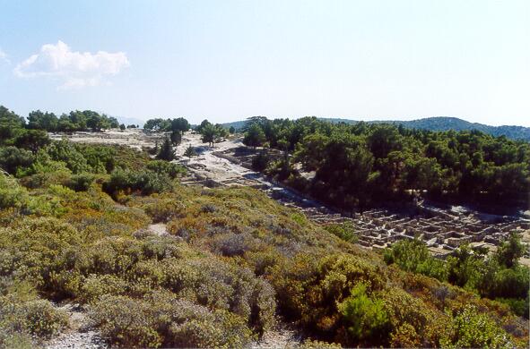
The Hellenistic city was built on three levels according to the Hippodamian system. On the summit of the hill was the Acropolis with the Temple of Athena and the Stoa. On the middle terrace was the settlement and lower down the Hellenistic Temple, Doric Fountain-house, Agora and Peribolos of the Altars. The area was embellished with numerous votive offerings, stelai and plinths with statues. The earthquake of 142 BC destroyed the city for the second time.

|
|
Clickable plan of Camirus (Click the image for a full screen view) |
|
|
Camirus from NE (Click the image for a full screen view) |
The Archeological Excavations
The Acropolis and the cemeteries were first excavated by A. Salzmann and A. Biliotti in the last century (1858-1865) and Biliotti continued in 1880. In 1912-1913 and 1928-1930 during the Italian occupation of the island, the Italian Archaeological School began a systematic excavation of the area together with restoration work which continued until the end of the 2nd World War.
Acropolis and Precinct of Athena Camiras
On the Acropolis of Camirus was the sacred precinct of Athena Camiras (also Kamiras or Kameiras). Parts of the enclosure wall are preserved in the south part of the plateau, as well as the foundations of the Temple.
The Doric Temple was probably tetrastyle peripteral (with porticos on all four sides) surrounded by a peribolos (the circular wall that enclosed the entire holy site), dating from the late 3rd - early 2nd cent. BCE. It replaced a previous Classical Temple which was destroyed by the earthquake of 226 BCE.
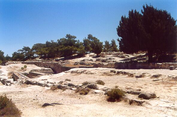
There is a very impressive cistern to the north of the Temple, dating from the 6th - 5th cent. BCE. This cistern fell into disuse in the late 3rd - early 2nd cent. BCE, when a large stoa was erected along the Acropolis plateau.
The stoa consisted of two rows of Doric columns with 200 m long and shops or lodgings at the rear for the worshippers. The columns at the front supported an architrave with metopes, triglyphs and a cornice (3rd - 2nd cent. BCE).
There was an impressive water supply system under the floor with wells (with covers, according to an inscription), subterranean tanks and terra-cotta water pipes, which replaced the earlier reservoir.
It formed an imposing backdrop dominating the city and offered the inhabitants of ancient Camirus, as it does the modern visitor, a panoramic view over the sea and the surrounding agricultural area.

|
|
Clickable plan of the Sanctuary (Click the image for a full screen view) |
Hellenistic Temple
At the north-west edge of the Agora Square stands the restored columns of a distyle Doric Temple made of poros, with two columns in antis, with a pronaos (an entrance-hall), naos (the sacred chamber where the cult statue was kept) and opisthodomus (a porch at the rear), which dates from the late 3rd - early 2nd cent. BCE.
The base of the cult statue is preserved in the naos and behind was the treasury, a pit cut into the floor to hold the money of the Temple. It was probably dedicated to Pythian Apollo.

|
|
The Hellenistic Temple (Click the image for a full screen view) |
Altar Enceinte
On the northeast side of the Fountain Square is preserved a Hellenistic Sanctuary dedicated to the Gods and Heroes of Camirus, with altars within an enclosure. This was probably the Hierothyteion of Camirus, known from inscriptions.
The inscribed altars were erected on two levels and dedicated to different deities (Agathos Daemon, Artemis, Zeus, Poseidon and others). There are remains of a large oblong altar dedicated to Helios on the first level.
A semicircular dais in front of the Peribolos of the Altars carried a votive offering.

|
|
Altar Enceinte (Hierothyteion) (Click the image for a full screen view) |
GALLERY

Hexapolis map.
|

Clickable Plan of Camirus. |

City (right) and Hellenistic Stoa (left) from NE.
|

The Hellenistic Stoa from NE.
|

The city (center) and the Hellenistic Stoa (top) from N. |

The main street of Camirus (center) and the Hellenistic Stoa (top)
from N.
|
The Cistern (left), the Hellenistic Stoa (center) and the Temple
(top) from NW.
|

The Hellenistic Stoa (center) and the Temple (top) from NW. |

Clickable plan of the Sanctuary. |

The Hellenistic Stoa from E. |

The Pronaos of the Temple of Athena Camiras from E. |

The Naos of the Temple of Athena Camiras from E. |

The North wall of the Temple of Athena Camiras from NE. |

The North wall of the Temple of Athena Camiras from N. |

The North wall of the Temple of Athena Camiras from NW. |

The West wall of the Temple of Athena Camiras from NW. |

The Opisthodomus of the Temple of Athena Camiras from W. |

Athena and her adopted son Erichthonius.
|

The Hellenistic Temple from E.
|

Hellenistic Temple N. |

Altars Enceinte SW 2. |

The Altars Enceinte from SW. |
Tourist Information
The site of ancient Camirus (also Kamiros or Kameiros) is 36 km southwest of Rhodes city, Rhodes island, Greece. The district of Kameiros stretches along the northwest coast of the island close to Cape Agios Minas (ancient Mylantion) in the foothills of Mt Akramytis.
Bus, car and taxi services bring most of the towns and villages within easy reach of the capital.
The nearby fishing harbour of Skala Kameirou makes a good place for lunch. Try the Symi shrimp or the octopus.
Other Views
- Perseus Image: Overall view of Kameiros Acropolis from N.
- Notice the partialy reconstructed Stoa on the top of this picture.
- Bouger et Voyager: Visiter Kamiros sur l'île de Rhodes
- Greek Travel Pages: Archaeological Site of Kameiros
- Greeka: Ancient Kamiros in Rhodes, Greece
- Rodes Guide: Ancient Kamiros, Rhodes
See also
- Perseus Site Catalog: Kameiros
- Perseus Encyclopedia: Kameiros
- Timeline: Hellenistic period
- Harpers Dictionary of Classical Antiquities (1898): Camirus
- The Princeton Encyclopedia of Classical Sites: RHODES (including Ialysos, Kameiros, Lindos, Vroulia, the city of Rhodes, Mt. Atabyrion)
- Hellenic Ministry of Culture: Kamiros
Source
Location
Home » Museum » Temples Gallery » Sanctuary of Athena Camiras at Camirus